Underwater Waterfall Mauritius: How to See It at Le Morne
Underwater Waterfall in Mauritius: What It Is & How to See It
Updated 16 November 2026
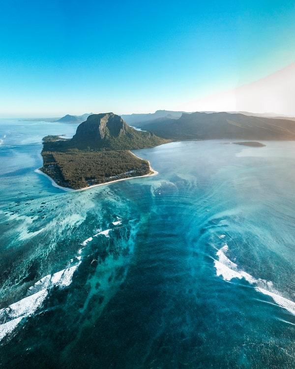
The underwater waterfall in Mauritius is one of the most extraordinary views on the island, and there is no waterfall under the sea. The photographs are real; the cascade is an optical illusion. Pale sand and sediment, reef structure, changing water depth and the contrast between turquoise shallows and deep blue ocean line up from the air to create the unmistakable shape of a vast falling curtain off Le Morne.
One detail most people get wrong: you cannot see the full illusion by climbing Le Morne Brabant. From the mountain you get the reef, the lagoon and the colour changes, but the geometry is wrong for the classic aerial effect. To see the formation as it appears in the famous photographs, you need to be above it — normally in a helicopter or a seaplane.
This guide explains what you are actually looking at, why the viewing angle decides everything, and how the reef passes, channels and lagoon structure around Le Morne fit together once you know how to read them.
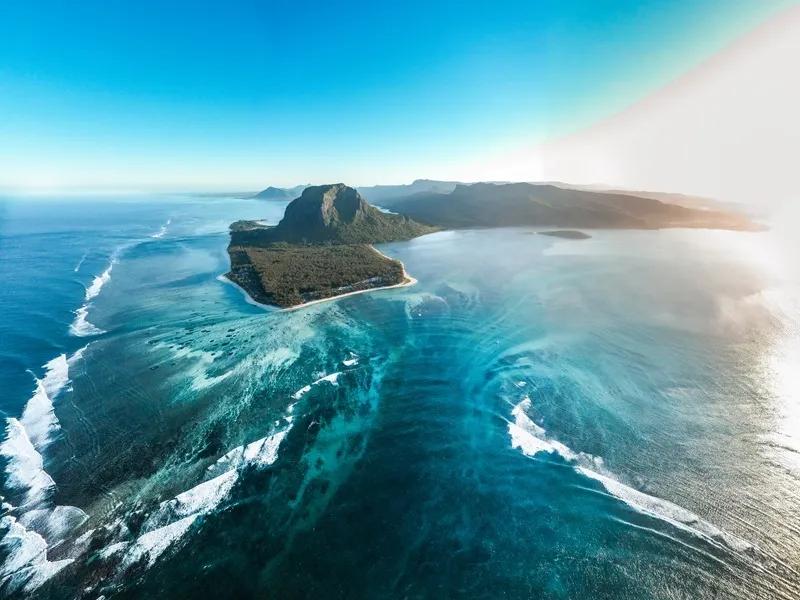
The iconic underwater waterfall at the south of Le Morne, Mauritius
Quick facts
● Where: off the Le Morne peninsula, south-west Mauritius, in the Black River district
● What it is: an optical illusion created by sediment movement, seabed topography and colour contrast — not a waterfall
● Best seen from: a helicopter or a seaplane
● From the beach: no. The effect does not read at sea level
● From the Le Morne summit: a rough outline at best, not the aerial formation in the photographs
● From a boat: no, for the same reason as the beach
● Can you swim there: the water above it is used by swimmers, surfers and kitesurfers, but you will see nothing of the effect from in it
● Weather dependent: yes, heavily. Cloud, wind and visibility decide whether you fly
● Nearest landmark: Le Morne Brabant, the 556-metre basalt monolith and a UNESCO World Heritage Site
Is the underwater waterfall in Mauritius real?
The view is real. The waterfall is not. Nothing pours through a hole in the ocean, and there is no vertical column of seawater falling beneath the surface. What looks like a cascade is the product of underwater topography, sand and silt, moving water and a very specific aerial perspective.
Mauritius is ringed by reefs, lagoons and a broad submarine platform. Around Le Morne, pale shallow water meets much darker ocean beyond the reef system, and sand and fine sediment are constantly shifted by waves and currents. Seen from high above, those pale streaks appear to stream away from the peninsula into the darker sea, while the depth and colour contrast makes the seabed look as though it drops away vertically.
"Underwater sandfall" is closer to the truth than "underwater waterfall." The water itself is not falling.
Air Mauritius, the national carrier, says the same thing on its own site: real underwater waterfalls do not exist, and what visitors see is an optical illusion caused by shifting sand and silt and the flow of underwater currents.
If you want to compare it with waterfalls that really do fall, see our best waterfalls in Mauritius guide.
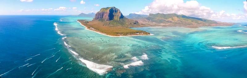
Why you cannot see the underwater waterfall from Le Morne Brabant
This is where the physics matters, and it is the single most useful thing on this page, because a lot of visitors climb the mountain expecting the photograph.
Climbing Le Morne gives you height. Height alone does not create the illusion.
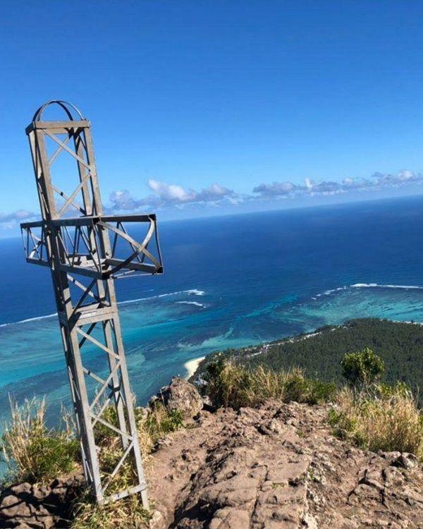
View of teh underwaterwaterfall from Le Morne Mountain
● The mountain rises a little over 500 metres, but the underwater formation sits offshore from the summit, not beneath it
● That means you are looking outward and downward at a shallow angle, not almost vertically down onto the seabed
● The classic photograph works because several visual layers line up in a single frame: the pale lagoon floor, the reef edge, the sediment streaks, the darker offshore water and the shape of the peninsula
● From the summit those layers are foreshortened. Distance compresses the scene, and features spread across the sea floor appear to overlap when you look across them from the side
Think of a long road. From directly above you see its full width, its bends and its junctions. From a low angle several kilometres away, the same road looks narrow and its sections seem to merge. Le Morne's summit creates exactly that problem.
Water adds a second obstacle:
● At a shallow viewing angle, glare from the sea surface and the reflection of the sky mask much of the subtle seabed contrast
● Looking more vertically through the surface cuts that reflection and makes the pale underwater patterns far easier to separate
● This is also why polarised sunglasses help enormously on a flight, and why a window seat angle matters more than altitude
The limitation is not that Le Morne is an unimpressive viewpoint — it is spectacular. It is simply in the wrong position, and not high enough relative to an offshore formation, to reproduce the aerial illusion. From the summit, expect a panoramic view over the lagoon, reef and open ocean. Do not climb it expecting the helicopter photograph.
Be sceptical of listings that advertise summit views "of the underwater waterfall." Some do. They are overselling what the geometry allows.
If the mountain is part of your plans, use our Mauritius hiking guide for the climb itself rather than treating it as a substitute for a flight.
Where exactly is the underwater waterfall?
The illusion lies offshore from the Le Morne peninsula on the south-west coast of Mauritius, below the outline of Le Morne Brabant. The mountain and peninsula are what make the photographs instantly recognisable: the turquoise lagoon narrows towards the tip of Le Morne before meeting the reef and the open Indian Ocean.
This stretch of coast is more complex than it looks from the beach:
● Shallow lagoon water over pale sand
● Reef flats that nearly break the surface
● Channels cut through the reef, which are deeper and darker
● Deeper outer-reef water beyond the barrier
● Open ocean past that
Those depth changes are exactly what produce the extraordinary range of blues seen from the air — and, as the sections below explain, some of the dark lines in an aerial photograph are channels rather than part of the illusion.
For the wider region, beaches and road-trip stops, see our West Mauritius travel guide and our Le Morne and Chamarel guide.
How to see the underwater waterfall
By helicopter
A helicopter gives the clearest and most controllable view, because the aircraft can approach from above and place the peninsula, the reef and the darker ocean into one composition.
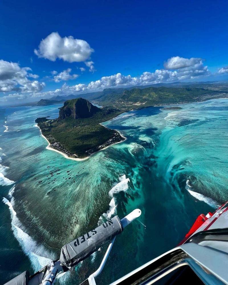
● The illusion becomes obvious as the viewing angle steepens, which is why a pilot who can hold position and reposition matters more than raw flight time
● Helicopters carry more passengers than seaplanes, which suits families and groups travelling together
● Routes commonly combine the waterfall with Le Morne, Chamarel and Black River Gorges
● Departure helipads vary by operator and by weather on the day
For flight options, durations and booking, use our dedicated Underwater Waterfall helicopter tour page. This article deliberately avoids repeating prices and operator details that change.
By seaplane
A seaplane is a different experience: a water take-off, a low scenic flight and an aerial pass along the Le Morne coastline.
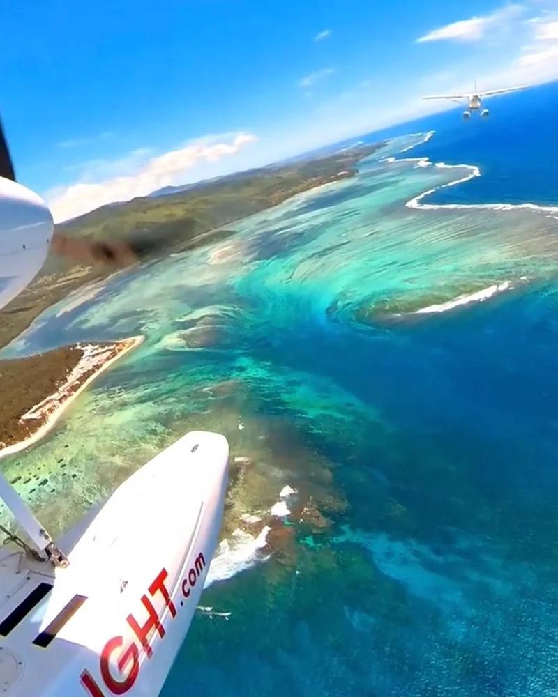
● Seaplane operations in this area work from La Prairie, beside Le Morne itself, which puts you over the formation within minutes of leaving the water
● These are very small aircraft. Expect tight capacity, published passenger weight limits and preparation time on the ground beyond the quoted air time
● Less ability to circle and reposition than a helicopter, which matters if photography is the priority
Compare current routes in our seaplane flights in Mauritius guide.
Check the route names Le Morne — there is more than one "underwater waterfall"
This is the booking mistake that catches people out, and almost nobody warns about it.
● Several operators sell east-coast flights over what is marketed as the "Eastern Underwater Waterfall" — a separate sediment formation, flown from eastern departure points on routes taking in Île aux Cerfs and Palmar
● At least one operator states plainly in its own listing that the eastern illusion is not to be confused with Le Morne's
● The famous image — mountain, turquoise lagoon, vast pale cascade — is Le Morne, in the south-west
● Before you pay, confirm the published route explicitly names Le Morne or the south-west coast
The listings look near-identical at a glance. A 20-minute flight from the east coast will not take you to the formation in the photograph.
From a boat, the beach or in the water
You can cross the surrounding lagoon, swim nearby or travel by boat without ever seeing a waterfall. At sea level the surface looks like ordinary ocean and lagoon water.
● The feature only resolves when you can look down across a large enough area to take in the pale sand, the reef geometry and the deep blue water together
● From sea level that large-scale pattern is compressed into a thin band on the horizon, and the contrast that creates the illusion is lost entirely
● Any boat trip sold as a way to see the underwater waterfall is overselling what optics permit
If you are visiting the coast without flying, the beach is still worth your time. See our Le Morne Beach guide.
What is a "passe" in Mauritius?
A passe is a natural opening or channel through the coral reef. The word is French, and it is used routinely in Mauritius when talking about reef passages. These gaps matter because the reef is otherwise a physical barrier between the protected lagoon and the open ocean.
● Boats use passes to enter and leave lagoons without crossing shallow coral
● Water uses them too. Waves push water over and through the reef into the lagoon, tides rise and fall, and all that water has to return to sea
● The deeper openings concentrate part of that return flow, which is why currents near a pass can be far stronger than in the surrounding lagoon
● Internationally, reef passages are recognised as ecologically distinctive features that link open ocean to sheltered lagoon and support exceptionally diverse and abundant marine life
A peer-reviewed study of Le Morne lagoon itself puts numbers on this. Research published in Hydrobiologia measured water depth and currents across a grid inside the lagoon and found:
● Current speeds just outside the reef above 0.5 m/s, against below 0.32 m/s inside the lagoon — the reef barrier substantially slows the water
● The lagoon classified as "restricted", with well-defined tidal circulation modified by wind
● Surface and bottom currents generally running in the same direction: northward on the flood tide, southward on the ebb
● Dense fields of branching Acropora coral reducing surface current speed by as much as 87%
That last figure explains a lot about why a lagoon can feel like a swimming pool in one spot and tug at you a hundred metres away. It also explains why a pass looks deceptively calm from a distance while carrying fast-moving water underneath.
Safety note — read this before going near a pass:
● A reef pass is not a casual swimming shortcut to the open sea
● Current strength changes with tide, swell and weather, and the published figures above are averages rather than guarantees
● Surfers at Le Morne describe the whole lagoon draining towards one large exit — the pass is where that water goes
● Leave pass navigation to experienced boat operators, and pass diving to qualified divers with a local dive centre
● Do not try to reach a pass or the offshore "waterfall" simply because it looks close on a map
For a fuller explanation of reefs, lagoons and passes around the island, see our Mauritius lagoons guide.
Passe St Jacques: the famous reef pass near Le Morne
Passe St Jacques is often confused with the underwater waterfall, because both sit in the dramatic south-west reef system around Le Morne. They are not the same thing. The underwater waterfall is an aerial optical illusion offshore. Passe St Jacques is a real channel through the reef that you can dive.
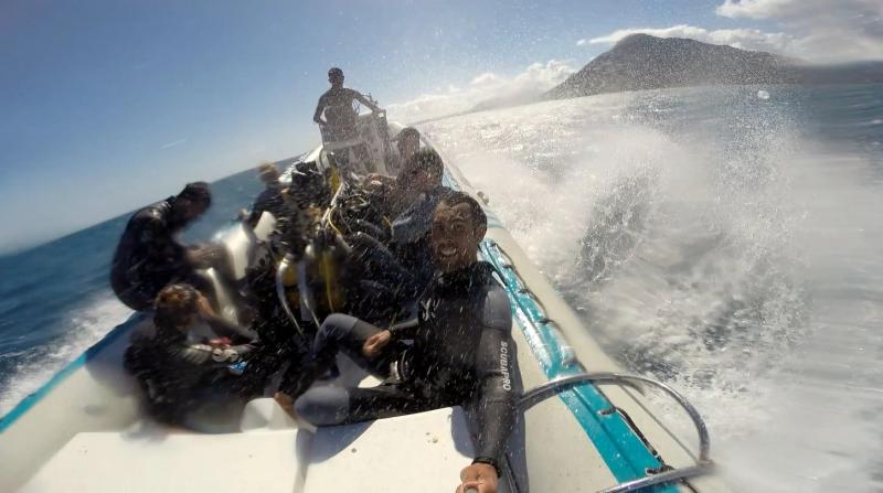
What the dive actually involves:
● It is a drift dive. The current carries divers along the pass rather than requiring them to swim against it
● Dive operators commonly describe it starting in the lagoon at under 5 metres, with the current drawing divers down through coral walls to a maximum of around 30 metres
● It is consistently marked advanced divers only, because there is always current — sometimes mild, sometimes strong
● Several descriptions note divers reaching a point in the structure where they can hold onto rock and wait, watching the channel
Why the site has a big-fish reputation:
● Moving water concentrates nutrients, small fish and prey around the channel edges, and predators use those zones to feed
● PADI describes the drift dive off Pass St Jacques as where bull shark, barracuda, and grey and whitetip reef sharks are often spotted
● ScubaCaribe, whose dive centre sits at the foot of Le Morne Brabant, promotes it as a drift dive where bull sharks and barracudas ride the currents
● Other operators and dive databases add eagle rays, stingrays, turtles, trevally, tuna, moray eels and large crayfish to the list
Shark sightings are never guaranteed. Treat Passe St Jacques as a high-energy reef-pass ecosystem rather than a staged shark dive. The attraction is the combination of current, topography and the possibility of big-fish encounters — and the same flow that makes it exciting is why it deserves respect.
One point to verify with your dive centre. Most sources place Passe St Jacques at Le Morne on the south-west coast, and the dive centre that most actively promotes it is based there. At least one reputable operator, however, describes a "Passe St Jacques" off the south-east coast near Mahébourg. Mauritius has several named reef passes and the names are not always used consistently, so confirm the departure point and the site with whoever is taking you.
Divers can read more about this site and other reef, wreck and drift dives in our best diving spots in Mauritius guide.
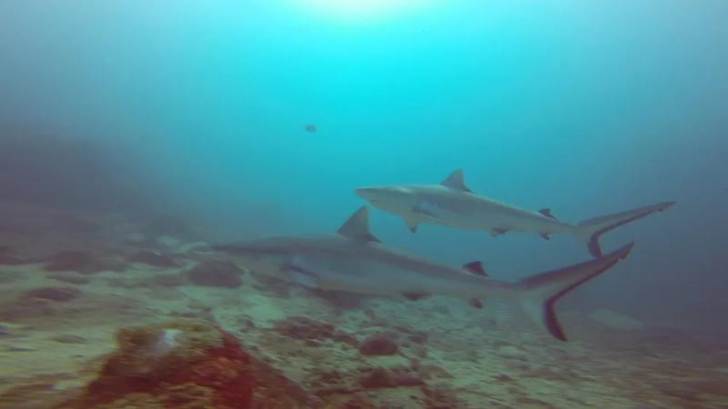
Black tip shark at Passe St Jacques
There is another pass nearby: Passe de la Prairie
Passe St Jacques is not the only break in the south-west reef.
● Official Le Morne Cultural Landscape mapping also identifies Passe de la Prairie nearby
● A second named opening, Passe de L'Ambulante, is mapped as a reef break in the same stretch of coast, at roughly 20.44°S, 57.31°E — it is well known to surfers and appears on surf-forecast charts as a consistent reef spot
● Both are part of the same wider system of lagoon, reef and deep channel around Le Morne, and both receive far less attention than Passe St Jacques in recreational dive marketing
Why this matters for reading an aerial photograph:
● From the air, passes appear as darker blue cuts through the pale reef, because the water in the channel is deeper and waves break on the reef either side
● To someone seeing an aerial image for the first time, those openings can easily be mistaken for part of the underwater-waterfall illusion
● Do not treat every dark line in an aerial image as the underwater waterfall. Some are simply deeper reef channels
Historically these channels mattered for more than diving. The Le Morne Heritage Trust Fund records deep channels connecting the open sea with the lagoon and their significance as entry points used by vessels. Today they remain part of the working geography of this coast — routes for boats, for moving water and for marine life.
Once you know what a pass looks like, the aerial landscape around Le Morne becomes far easier to read, and the illusion itself becomes easier to pick out from everything else going on in the frame.
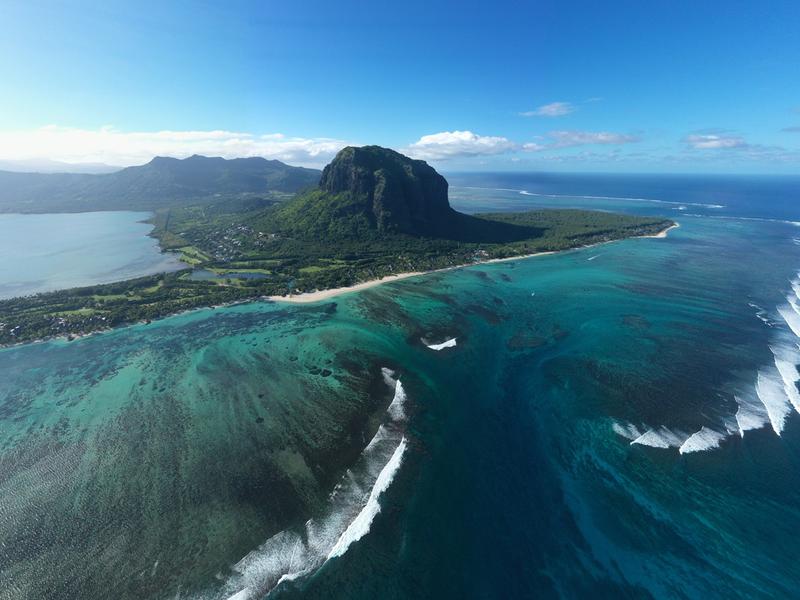
Another Mauritius illusion: the "underwater river" of Bel Ombre
Le Morne is not the only place where the shape of a Mauritian lagoon tricks the eye. From above Bel Ombre, on the south coast, a different pattern appears — less like a waterfall and more like a dark river running beneath the sea. We use "underwater river of Bel Ombre" here as a descriptive label for the visual effect, not as an official geographic name.
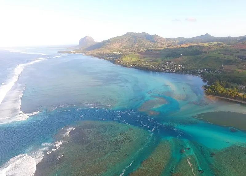
The amazing Passe at Bel Ombre
It belongs to the same family of optical effects, but the geometry is different.
● Bel Ombre has a broad reef-protected lagoon with very shallow areas and deeper channels used by boats
● Where a deeper channel cuts through pale sand, reef or seagrass, the water above it appears darker
● From altitude that dark ribbon can look exactly like a river flowing across or beneath the lagoon
The colour is doing most of the work:
● Shallow water over light sand reflects more light and appears turquoise or pale blue
● A deeper channel absorbs more light and appears darker
● When the channel winds, your brain reaches for a familiar pattern from land — a river running through a landscape — and applies it
The lagoon's own composition explains why the contrast is so strong there. Bel Ombre's conservation documentation describes mixed seagrass meadows in the sheltered parts of the lagoon, four of the island's eight seagrass species, and patch reefs sitting as small outcrops surrounded by sand. Dark seagrass and reef against bright sand is precisely the palette that makes a channel read as a river from the air. The same documentation notes that the most human-affected areas of this lagoon are near the shore and around boat traffic areas — in other words, along the channels themselves.
This is why the Bel Ombre feature should not be described as a real underwater river. Nor is it necessarily the same sedimentary process as the Le Morne sandfall. The shared ingredients are bathymetry, seabed colour, moving water and aerial perspective. At Le Morne those produce the illusion of a steep cascade; at Bel Ombre, different lagoon depth and channel shape produce something that looks like a river.
It is a good reminder that Mauritius looks completely different from the air. The lagoons are not flat blue swimming pools. They are complex landscapes of sand, reef, seagrass, channels, passes and constantly changing depth.
Best time to see the underwater waterfall
There is no month that guarantees the view. Light and cloud on the actual day matter far more than a seasonal average. The illusion becomes easier to read when sunlight reaches the shallows and the contrast between pale water and deep ocean is strong.
● Aim for a clear day with good visibility rather than choosing a month because a website calls it the best season
● Late morning through early afternoon gives the strongest overhead light, putting maximum light into the shallows — but flight operators decide whether conditions are suitable
● Very low sun flattens the effect and adds glare across the water surface
● Book the flight early in your holiday, never on your final day, so you have room to move it if weather forces a cancellation
● Keep a flexible day in the south-west so a reschedule costs you a rearrangement rather than the experience
● During cyclone season and unsettled weather, flexibility matters more than any fixed itinerary
● Wind matters as much as cloud, particularly for seaplane operations working off a beach
For seasonal planning, use our best time to visit Mauritius guide, and check our Mauritius cyclone season guide if you are travelling during the warmer months.
Can you swim over the underwater waterfall?
Yes — you can be in the sea around Le Morne without falling anywhere, because there is no waterfall BUT THIS IS HIGHLY NOT RECOMMENEDED. The surface above the illusion is ordinary ocean water. The famous effect exists only from above, where your eye can read the large-scale seabed and colour pattern.
That does not make every part of this coast a swimming area:
● Reef passes, waves, currents and open-ocean conditions are separate hazards, and the measured current difference between inside and outside the reef is substantial
● Enjoy swimming and snorkelling in suitable lagoon areas — the Le Morne lagoon is genuinely lovely, and the reef at nearby La Prairie grows unusually close to shore
● Watch for kitesurfers, who use this lagoon heavily when the wind is up
● Do not try to reach a reef pass or the offshore formation because it looks close on a map. It is not, and there is nothing to see when you get there
Le Morne is more than the photograph
The aerial illusion gets millions of views online, but Le Morne Brabant should not be reduced to a backdrop.
● The Le Morne Cultural Landscape is a UNESCO World Heritage Site, inscribed in 2008 under cultural criteria (iii) and (vi)
● It is recognised for its association with maroons — enslaved people who escaped and used the mountain's isolated cliffs, caves and summit as refuge, through the 18th and the early years of the 19th centuries
● UNESCO describes the mountain as an exceptional testimony to maroonage, or resistance to slavery, and as a symbol of the fight for freedom, of suffering and of sacrifice
● The significance reaches beyond Mauritius, connecting to the regions the enslaved came from — the African mainland, Madagascar, India and South-East Asia
● Criterion (vi) rests substantially on the longevity of the oral traditions associated with the maroons, carried by the Creole community of Mauritius
● The Slave Route Monument sits at the foot of the mountain and is open to anyone. It takes a few minutes, and it changes how the view reads
● Mauritius marks the Abolition of Slavery on 1 February each year, and Le Morne is central to the commemoration
The cliffs that make the mountain so dramatic from a helicopter are the same cliffs that made it defensible from the ground. If you fly over the underwater waterfall, spend some time understanding the landscape beneath you. The history gives the view a meaning the viral image alone cannot.
For a fuller day around the area, see our 25 things to do in Le Morne and Chamarel.
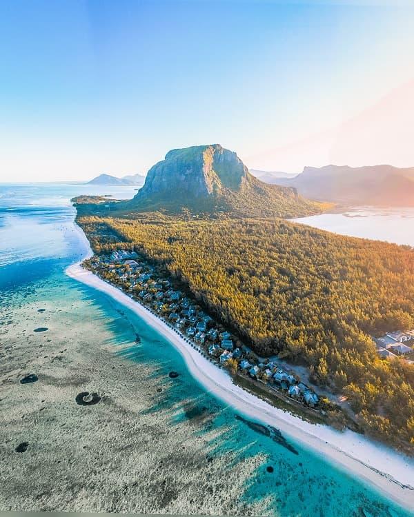
Make a day of it in south-west Mauritius
A scenic flight is short compared with a full day, so build the rest of your itinerary around the south-west rather than driving to Le Morne only for the flight.
● Le Morne Beach — swim, walk the shoreline or simply relax after the flight
● Le Morne Cultural Landscape — give time to the mountain's history, not only the aerial view
● La Prairie — a relaxed coastal stop with one of the clearest ground-level views towards Le Morne, and a shallow reef close to shore
● Chamarel — combine the coast with the Seven Coloured Earth, the Chamarel waterfall or Ebony Forest
● Macondé — add the coastal viewpoint if you are driving between Le Morne and the south
● Black River Gorges — use the western viewpoints or trails if you want a nature-heavy day
● Diving at Le Morne — if you are certified and the conditions suit, this is where the reef-pass diving happens
A sensible shape for the day: flight in the late morning while the light is strongest, heritage and lunch in the early afternoon, beach or Chamarel to finish.
If you want to build it into a longer holiday, use our Mauritius itinerary plans.
Practical checks before you book
● Confirm the flight route specifically includes the Le Morne underwater waterfall, not an east-coast formation with similar marketing
● Ask where the flight departs from — helicopter and seaplane departure points differ, and so does the road time to reach them
● Add total transfer time to the flight duration when planning the day
● Read weather cancellation and rescheduling terms before paying, and ask whether a cancellation means refund, credit or rebooking only
● Ask how much notice you will get if conditions are unsuitable
● Book early enough in your stay to allow a weather-related move
● Check passenger weight and identification requirements, which seaplane operators apply strictly
● Check minimum age and any medical or mobility restrictions
● If photography matters, ask about seating and window arrangements rather than assuming every seat gives the same angle
● Bring polarised sunglasses for the flight, and a camera strap — loose items are usually prohibited in the cabin
● Do not plan the Le Morne hike as a substitute for the aerial view
● Do not enter Passe St Jacques or any reef pass as a swimmer. Currents near passes are significantly stronger than in the lagoon
Frequently asked questions
Is the Mauritius underwater waterfall real?
The photographs are real, but the waterfall is an optical illusion. Sand, sediment, seabed shape, depth and colour contrast create the appearance of a cascade when viewed from above. Air Mauritius states on its own site that real underwater waterfalls do not exist. Nothing is falling, and there is nothing to see beneath the surface.
Can you see the underwater waterfall from Le Morne Brabant?
Not in the classic form. From the mountain you can see the reef, the lagoon and the colour changes, but the viewing angle is too shallow and too far to one side to reveal the full aerial illusion. The formation sits offshore from the summit rather than beneath it, so you look across it instead of down onto it.
Why can a helicopter see it when the mountain is over 500 metres high?
Position matters as much as altitude. A helicopter can move out over the offshore feature and look down steeply, while the summit stays fixed on land and looks across the formation at an oblique angle. Surface glare and sky reflection also mask seabed contrast at shallow angles, and a steeper view cuts straight through that.
Can you see it from a boat?
No. From sea level the large seabed pattern is compressed into a thin band and the contrast that creates the illusion is lost. The effect needs bright shallows and deep water seen side by side from above, which is geometrically impossible at the surface.
Can you swim over it?
You can be in the surrounding water, because there is no physical waterfall. However, outer-reef water and reef passes carry strong currents and are not casual swimming areas. Measurements at Le Morne found currents outside the reef more than fifty per cent faster than inside the lagoon. Swim and snorkel in suitable lagoon areas instead.
What is a passe in Mauritius?
A passe is a natural channel or opening through the coral reef. Boats use passes to move between lagoon and open ocean, and water returning seaward concentrates through them, which is why currents near a pass are much stronger than elsewhere in the lagoon. They also attract marine life, because moving water concentrates nutrients and prey.
What is Passe St Jacques?
Passe St Jacques is a real channel through the reef near Le Morne, separate from the underwater-waterfall illusion. It is dived as a drift dive, typically starting in the lagoon at under 5 metres and reaching around 30 metres, and it is marked for advanced divers only because there is always current.
Are there sharks at Passe St Jacques?
Shark encounters are part of the site's diving reputation. PADI describes the drift dive off Pass St Jacques as where bull shark, barracuda, and grey and whitetip reef sharks are often spotted, and ScubaCaribe promotes it as a dive where bull sharks and barracudas ride the currents. Sightings are never guaranteed.
Is there another reef pass near Le Morne?
Yes. Official Le Morne mapping identifies several openings, including Passe de la Prairie, and Passe de L'Ambulante is mapped nearby as a reef break well known to surfers. These deeper channels appear as dark cuts through the pale reef in aerial photographs and are easily mistaken for part of the underwater-waterfall illusion.
What is the underwater river of Bel Ombre?
It is a descriptive name for an aerial lagoon illusion on the south coast, where a deeper channel appears as a dark river running through shallower water. It is not a real river beneath the sea. Dark seagrass meadows and patch reefs against bright sand make the contrast especially strong at Bel Ombre.
What is the best way to see the underwater waterfall?
A helicopter or a seaplane route that specifically overflies the Le Morne formation. Helicopters offer more control for photography and more capacity for groups; seaplanes offer a water take-off from La Prairie and the shortest hop to the formation. Check that the route names Le Morne before booking.
What is the best time of day?
Clear conditions and good overhead light matter most. Late morning to early afternoon usually gives the strongest contrast, because high sun puts maximum light into the shallows. Very low sun flattens the effect and adds glare. Weather and operator advice should decide the actual flight time.
What happens if my flight is cancelled for weather?
Cancellations are routine rather than exceptional, and operators cancel for cloud, wind, visibility and sea state. Read the rescheduling terms before paying and ask whether a weather cancellation means a refund, a credit or a rebooking. The practical protection is to book early in your holiday so the flight can be moved.
Final local tip
See the illusion for what it really is and it becomes more interesting, not less. The underwater waterfall in Mauritius is not a hidden hole in the Indian Ocean. It is the visible result of reef, lagoon, sediment, current, depth and perspective lining up almost perfectly from the air.
Once you can read the passes, the channels and the changing depth around Le Morne and Bel Ombre, the coastline stops looking like a flat strip of blue and starts looking like what it actually is — an underwater landscape, with its own structure, its own weather and its own rules.
Explore this topic
Get new Mauritius guides by email
Join the Mauritius Explored list for trip ideas, practical updates and downloadable planning help.

Written by the Mauritius Explored editorial team, a Mauritian travel guide focused on beaches, activities, local places, and practical island planning.
Local Mauritius travel research, itinerary planning, and destination coverage since 2011.